Monday, November 10, 2014

Crossing the Big Bend of Florida

Friday November 7th - Saturday November 8th

The Big Bend
After fueling in Apalachicola yesterday afternoon, Brett and Colin received a weather report that showed favorable travel conditions for the 180 mile, 18 hour traverse of the Gulf of Mexico to Clearwater which is bit farther south than illustrated by this map. They could have taken the coastal route but that consumes 3 days or more if the weather does not cooperate.

At 3:15 PM, they headed at 5 knots to what is described as the Big Bend of Florida Government Cut. The weather services said the 3-6 foot seas would diminish to 1-2 foot by 7 PM.  

At 4:16 PM, they proceeded out into the Gulf and experienced some rolling waves. They set the autopilot for Clearwater and the speed to 10 mph.  For the first 12 hours of the trip, they enjoyed hit good weather and 1-2 foot seas.  Around 3 AM however, they ran into the "back" of the rough seas.  In hindsight, they said they would have had better fortune if they had waited until 7 PM to leave for Clearwater.  

As you can see, there was a very beautiful moon and it gave them plenty of light which was part of the plan so at least one aspect worked out very well. 


They fueled up again in Clearwater upon arrival there on Saturday morning. The sunrise was gorgeous!


Saturday evening's port was Twin Dolphin Marina. Colin was able to visit with long time friends, Paul and Marni.

Friday, November 7, 2014

Florida’s Panhandle to Apalachicola and then across the Gulf of Mexico to Clearwater

Brett and Colin started early Wednesday morning Nov 5 after arriving at the Palafox Pier Marina on Tuesday afternoon. They were on the water at 6:45 am, filling the fuel tanks and refreshing familiarity with the boat after 35 days away from cruising.  

To begin with, they slowly navigated out to the intercoastal waterway.  When they found the buoy markers, they brought Late Date up on plane and cruised into a westbound 10 mph wind.  They stayed on plane most of the 110 mile trip - except the narrow 20 mile channel between Destin and Panama City.  


Their day ended with docking at the Panama City Marina, where they filled the fuel tanks and washed the salt water off the exterior.  They also flushed the salt water from the engines.

To everyone's delight, the reworked propellers delivered identical fuel consumption for the first time -.  85 gallons port and 85 gallons starboard!  As an added bonus, the Mercury Smartcraft systems also showed that Late Date used 171 total gallons of fuel.  At long last, Smartcraft's fuel numbers can be trusted.

Thursday, the crew plans to head to Apalachicola pending a favorable weather report.  On Wednesday, there were 4-6 foot seas on the gulf between Apalachicola and Clearwater.  Similar results tomorrow may cause us to postpone the gulf crossing until Friday.

Monday, November 3, 2014

Well the day is here!  Late Date is finally going to get to her new home. 

She is currently at the Palafox Pier in Pensacola, FL. Another gorgeous picture courtesy of Colin. 

Here is the current plan:

Brett and Colin arrive in Pensacola on Tuesday afternoon and prepare the boat for an early Wednesday trip from Palafox to Panama City, a distance of 100 miles.  They will stay at a marina there to refresh and refuel.  On Nov 6, they will head to Apalachicola which is 55 miles on the intercostal.  They will refuel mid-afternoon -  including those extra gas cans - before heading out to outside of the Goverment Cut. Noting that high tides occur Nov 6th at 4:40 pm and Nov 7th at 2:12 am, they intend to begin the trip to Clearwater under full moon and hopefully good weather. From Clearwater, they intend to anchor in Bradenton Beach to visit good friends Paul and Marni.  On Sunday Nov 9, they will leave for Fort Myers, then push on to Lake Okeechobee and Indian Town Marina. This will take 2 days. On Nov 12, they intend to be in New Smyrna Beach and travel on to Fernandina Beach to arrive late on Nov 12.  This may get delayed by a day but they pretty confident unless weather intervenes.  At some point in this trip - maybe at Ft Myers - friend Mike plans to hop on so there will be a trio bringing Late Date home.  

Can't wait for the pictures!


Tuesday, September 30, 2014

Destination Mobile Bay

Sunday September 29 began with a sunrise departure from Demopolis Yacht Basin to Demopolis L&D. Being a weekend day, there was considerable recreational use occurring on the Tenn-Tom and this slowed Late Date's progress. 

The planned refueling and night stop was to be Bobby's Fish Camp Mile 118.9. There were technical issues with the fueling station that required quite some time to correct. Compounding that frustration, the transient slips were exposed to significant barge wakes. With both issues, Brett, Colin and Bob decided to try an anchorage at Mile Marker 100 instead since they really needed to make Mobile, AL in good time on Monday.Hurrying out of Bobby's, they wanted to get ahead of a large tow pushing coal. They were unsuccessful and had a long wait on this the final lock of the trip to the Gulf. After traversing 50 L&D over the past 20 days and only waiting a total of 3 hours for commercial traffic, the Colin "shamrock" failed. 
Coal Tow

Sites of Mobile Bay, AL


Arriving at Mile 100, the shamrock continued to wilt.  The water was incredibly low and to anchor safely was nearly impossible.  Brett stayed awake all night to watch for tows since Late Date has to have at least 6 feet of water beneath her.  While her lights and ping radar were on, this does not guarantee that a recreational boat on anchor will be seen in time. In total, Brett hailed five passing tows of Late Date's location on his all night vigil. On Monday morning, Brett went to bed while Colin and Bob left anchorage to take Late Date out on her final 100 miles to Mobile Bay. 


Bob, Colin and Brett Dog River Marina, Mobile AL
Arriving finally at Dog River Marina, Mobile, AL,Late Date was using too much gas on the port side. This would make the Gulf run questionable until this is fixed so the decision was made over a hot meal and beer that they all needed a break from Late Date. Brett is heading back to Minnesota and work while Colin and Bob are renting a car and driving to Colin and Paulita's home in Fernandina Beach. The staff and marina at Dog River are good friends of the staff at Bayport Marina so Late Date will be well cared for.  

The next leg of Late Date's journey is to her new port of call and that will involve crossing the Gulf of Mexico to Clearwater FL and then either a short cut through Florida or an adventurous route around the state. Stay tuned for details since there are a few options in terms of Late Date's route and date of departure!

Saturday, September 27, 2014

From Midway Marina Columbus Marina MS to Demopolis Marina AL

On Friday September 26, the crew took Late Date from Midway Marina to Columbus Marina in Mississippi.  As Colin put it, the "shamrock" was working for them.  They made it through 4 L&Ds and arrived at Columbus by 1:15 PM.  Loud rock & roll was playing on someone's stereo in the marina. Colin said that he had to convince Brett and Bob to stop dancing and go do laundry. After that, all three took a courtesy truck into town to replenish groceries and have a hot meal. They had an early night and went to bed by 9:45PM. 

Friday also marked 2 weeks since Late Date left Bayport, MN. It seems such a short time to those of us reading the blog but this is very hard and tiring work. Hopefully the spectacular weather and scenery helps. The photos of sunrise over Columbus Marina, MS and as they departed it for the John Stennis Lock are stunning! 
Daybreak Over Columbus Marina

Heading Out
Hard at Work
We had a few emails about L&D passages maybe being over but no - sadly - they continued for them. Here is a map of the marinas so you can get a feel for the marinas mentioned in this part of the blog and where Demopolis is located relative to Mobile and - AT LONG LAST - the Gulf of Mexico.   
Tenn-Tom Marinas
The weather continues to be amazing and it appears to be holding for the upcoming 7 days.  Herons and egrets are interspersed with tows and barges.  
Egret

Heron

Tow and Barge

Tackling Tombigbee

Today, Bob, Brett and Colin left Kentucky Lake and had another eventful day after - wait for it - putting more fuel in the tank at the Aqua Yacht Harbor.
Fueling the Tank
Brett's Morning Coffee
Tombigbee River Alabama
The first stop was to be the Pick Wick Lake area. Leaving the harbor, they began their descent of the Tennessee Tombigbee waterway and entered the State of Mississippi.  In 1810, the citizens of Knox County, Tennessee (current location of Knoxville) petitioned the U.S. Congress to build the waterway that would shorten the distance by more than 800 miles for trade with New Orleans, Mobile and other ports along the Gulf of Mexico. Shortly after Alabama joined the union in 1819, the state hired an engineer to survey its rivers, including a possible connection with the Tennessee River. After a very controversial long battle and a comparatively short 12 years of construction, the Tennessee-Tombigbee Waterway was completed on December 12, 1984 at a total cost of nearly $2 billion.


Their day ended at the Midway Marina after getting through 3 locks including the Whitten L&D,  Mile 411.9, which has a lift of 84 feet and is the 4th highest single lift lock in the nation.  It is located in Tishomingo County near Belmont, MS.  Whitten L&D is the northernmost lock on the Tenn-Tom. The dam forms a 6,600-acre lake that joins the so-called Divide Cut canal, and ultimately connects the Tenn-Tom with the Tennessee River. 
From Late Date's Bridge Looking Out from Midway


Thursday, September 25, 2014

Kentucky Lake - Clear Water at Long Last


Getting an early start, Late Date enjoyed another beautiful sunrise. "Gas Hog" aka Late Date needed to be fueled up before departure.  

Once done, they departed for the amazingly beautiful Kentucky and Barkley Lakes. 
As background, Kentucky Dam creates the largest human made lake in the eastern United States. It backs up the Tennessee River for 184 miles and creates a lake that stretches south across the western tip of Kentucky and nearly the entire width of Tennessee. At maximum normal operating level, Kentucky Lake covers 160,300 acres. The Tennessee is the nation's fifth largest river within the lower 48 states in terms of flow. Kentucky Dam is just 22 miles upstream from Paducah, Kentucky where the Tennessee River flows into the Ohio. Water from the 40,200 square mile Tennessee Valley passes through the dam. This strategic location and the vast flood storage capacity of Kentucky Lake make it possible for Kentucky Dam to reduce or even temporarily shut off the flow of water from the Tennessee to help lower flood crests on the Ohio and Mississippi rivers. The five turbine-generators in Kentucky Dam powerhouse have a total capacity of 175,000 kilowatts. They harness the river's flow to generate up to 1.3 billion kilowatt-hours of electricity each year. In 1938 when it was decided to build the dam and create the Kentucky Lake & Lake Barkely, thousands of people had to be relocated since the Tennessee Valley Authority purchased over 170,000 acres of land to flood.  

Colin snapped a photo of one of the flooded farms - sort of amazing but sad to see.
Abandoned Farm


Kentucky Lake 

Kentucky Lake


Wednesday, September 24, 2014

So if you run out of gas on the water...???

Colin called last night to announce that they did NOT run out of gas.  He sounded so surprised.  

In his own words...
Sunrise
"We started the day at our anchorage near Cape Girardeau, MO.  We all slept well and were ready to go at first light around 615 AM. The Mississippi was murky and very active with tow boats and turbulence.  In some places, it looked like a really big tub of chocolate being stirred. We reached the mouth of the Ohio around 8 AM.  The Ohio was much cleaner and steadily moving – although we were now going upstream.  After 20 miles we began to worry about our fuel consumption.  At 3400 RPM we were pulling 15 knots and using too much fuel.  We slowed to 2600 knots.  We first encountered multiple tows and barges around Cairo.  As we made our way to the Olmstead L&D - which is under construction - the river cleared.
The Very Over-Budget, Over-Schedule Olmstead L&D
Further upstream L&D 53 was under water and we were able to float over the top.  Next came L&D 52 which seemed like it was held together with baling wire and duct tape.  It was a very slow rise of about 10 feet and we were locked down for 45 minutes. Eventually, the  new Olmstead will replace both 52 & 53. At this point, we were really beginning to worry about whether or not we could make it to our destination of the Green Turtle Resort on Lake Barkley.  We encountered 5 tows on the Cumberland River. Although taking the Cumberland instead of the Tennessee added about 20 miles, it was a better L&D for us to use.  Kentucky lock normally has 2 locks but due to high water, the auxiliary lock was closed and delays were predicted to be 4-6 hours.  
Fearless and Determined

About 20 miles from Barkley Lock, our port fuel gauge showed 1/8 remaining. The starboard tank showed nearly 3/8 remaining.  The fuel management display confirmed that we were using too much fuel.  The lock operator wanted us to hurry, so we decided to go for it and put the throttles at 3400 RPM. This buried the needle under "empty" on the port but ....the boat remained running.  The starboard tank finished the day at ¼. 
We made it through Barkley as it was getting dark and were relieved to get out of there. 
Obviously, we are looking forward to tomorrow' s refueling since this will hopefully shed light on the accuracy of the fuel gauges and management systems."

My obvious question to Colin was "so if you run out of gas on the water, what do you do"? His reply "You call Sea Tow and get an expensive tank of gas". I imagine you also do the walk of shame - however one would do that in a boat.  
Barkley L&D


Barkley L&D


Tuesday, September 23, 2014

The First Fuei Test - Using Spare Tanks

Caravan of Loopers Following Late Date
Leaving Hoppie's and Fabulous Fern early on Sept 23rd, Late Date had full spare gas containers on board. Bob, Brett and Colin felt confident that they would go the distance. All the Loopers followed in caravan and they made excellent time.
Looking North from Monday Night's Anchorage


Entering Little River Diversion Channel Anchorage
The total distance today was 110 miles to the Little River Diversion Channel anchorage (see red arrow on map below) and then refueled using all 50 gallons.  


Steve and Friends
The Looper crews are all good people and invited Bob, Brett and Colin to come visit them in the anchorage.  Steve Sterk came over to Late Date in their dingy and took all to another Looper yacht for cocktails.

Tomorrow, Late Date heads for Turtle Bay Resort up the Cumberland River. They need to make 140 miles and are leaving at 6:15 am.    

Monday, September 22, 2014

Hoppies - A Milestone and Memorable Destination

Sunrise over St. Charles
Late Date left Port Charles Marina at 630 AM Sunday and continued downstream where they met up with 4 "Looper" boats leaving Grafton and heading the same location as Late Date - Hoppies Marina. 
"Loopers"

A moment to define "Looper" = people who navigate the Great Waterways seen here in this map.  
Great Loop Cruise Routes

The guys decided to hang back with the Loopers as we navigated toward L&D 25.  The lockmaster hinted at a 2-3 hour delay.  Brett was able to convince him to let the group pass before a couple of up-bound tows.  

Late Date then lead the group to "Chain of Rocks" L&D 27.This is the FINAL lock on their journey on the Mississippi and merited a photo. 
After a short delay, Late Date lead the group through St. Louis.  


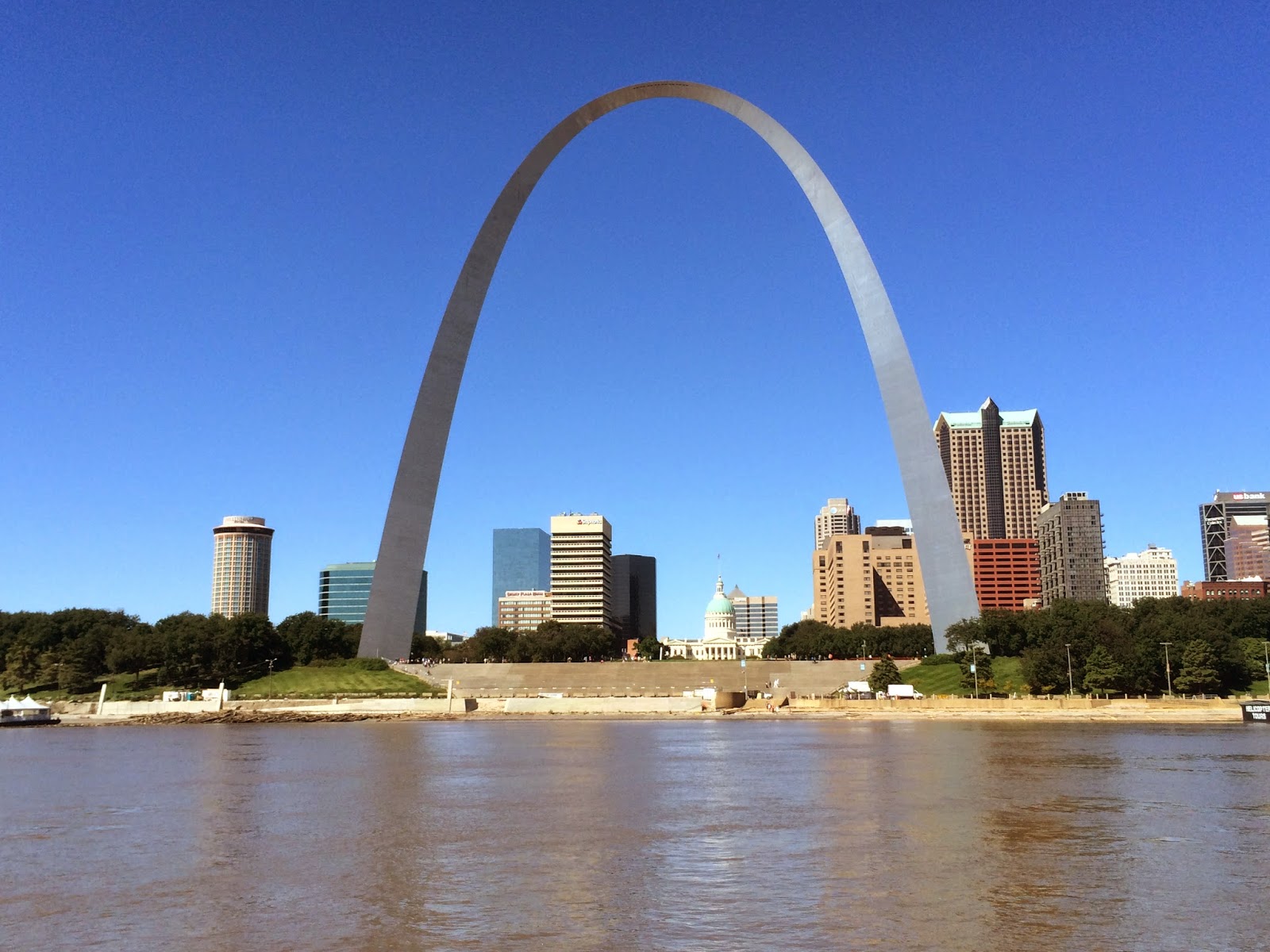
The skyline and the arch were gorgeous but the river south of St Louis was quick and filled with debris in the form of fallen trees and branches. 
Entering St. Louis, MO
The Arch


From here it was on to Hoppie's.  A moment to describe Hoppie's and its importance to all boaters (source http://www.greatloop.org ). Hoppie's Marina is located at Mile Marker 158.5 on the Mississippi River in Kimmswick, Mo. It is an important, strategic and essential stop for all recreational boaters heading South, because it is the last marina and the last consistently available fuel stop on the Upper Mississippi River. It is another 250 miles and 3 locks to Green Turtle Bay Marina, in Grand Rivers, Ky., on the Land Between the Lakes, and over 400 miles to Mud Island in Memphis, Tenn., on the Lower Mississippi. Hoppie's Marina is the last place to refuel, take on water, re-provision, do laundry, change or take on crew, do repairs, and make sure the boat and the crew are ready for a challenging section of the trip.

Three years ago, the Army Corps of Engineers constructed several river dikes just south of Hoppie's to make navigation easier, but the Hopkins family says the changes have reduced the depth of the water around their docks. While the channel remains deep, the dredging pushes silt towards the docks, and that makes it tough for big boats to stop at Hoppie’s.

At Hoppie's, Bob, Brett and Colin were greeted by Fern, her daughter and husband -Hoppy. For the O'Neill clan, Colin said to tell you that Fern is Auntie Phyllis.  
Colin and Fern

After refilling Late Date's tanks and the ten 5 gallon gas containers they brought along for this and another long stretch of the journey, they got to listen to Fern's description and stories of the current condition along our trip to Mobile.  They concluded the evening by sharing in a pot luck dinner.

With another 630 am start on Monday, they went to bed early Sunday evening.

Sunday, September 21, 2014

Dredging on the Mississippi to Keep Barge Traffic Moving

The Army Corps of Engineer dredging operation has had its work cut out for it this year on the Mississippi River.  Unusually, there have been four high water events in 2014 and - as the Late Date blog has noted - the river remains comparatively high and moving fast for this time of year.  
Dredging Operation


The dredging is a complicated process wherein engineers first map the river bottom, then lay out a rectangular area for the cutting operation and then decide how they will move the sand to shore. The sand is either left in place as a mountain of sand which dozers groom into place or it is made available to businesses that want it. A 9-ft deep dredge is the norm for keeping the channels open. This particular operation was a first for the Late Date crew to see in that it had a long pipeline through which the sand was being pumped to an island.
Pipeline from Dredge to Shore
The dredge crew lives on the water for the duration of the operation.  As many of you know, there have been backlogs of barge shipments both north and south on the Mississippi this year.  Dredging operations are on full alert since the heartland not only needs to ship fall harvest to awaiting ships but also must receive cement and salt for construction and (gulp) winter roads. 
Floating Hotel
Barges are economical, efficient and readily available — when the river is clear. Per the Iowa Department of Transportation www.iowa.gov, a grain barge holds 12,500 tons or 52,000 bushels of grain. One barge carries the equivalent of 13.4 jumbo train hopper cars or 58 large semi-trucks. 

An estimated 60 percent of all U.S. grain exports are shipped on the Mississippi through New Orleans and the Port of South Louisiana.